Session 1: Saturday 9 am September 9, 2023 Meet at Riverside HS parking lot
Buffalo Maritime Center

From its beginnings as a bright idea in the Design Department at Buffalo State College, to its present status as an independent not-for-profit, the Buffalo Maritime Center (BMC) has played - and continues to play - a central role in elevating awareness and appreciation of Western New York’s rich maritime heritage.
The Buffalo Maritime Center had its origins just over three decades ago as a creative experiment for teaching 3-D design at Buffalo State College called the Center for Watercraft Studies. From a design point of view, there are few objects better than a boat for studying and exploring form and function and human culture. The Center for Watercraft Studies offered an introductory course in Wood Design and taught eleven female students how to build a wooden kayak. We began collecting and restoring important local boats, and in several cases constructed full sized replicas of lost vessels. Over the years, the Center for Watercraft Studies evolved into what we know today as the Buffalo Maritime Center.
The Buffalo Maritime Center had its origins just over three decades ago as a creative experiment for teaching 3-D design at Buffalo State College called the Center for Watercraft Studies. From a design point of view, there are few objects better than a boat for studying and exploring form and function and human culture. The Center for Watercraft Studies offered an introductory course in Wood Design and taught eleven female students how to build a wooden kayak. We began collecting and restoring important local boats, and in several cases constructed full sized replicas of lost vessels. Over the years, the Center for Watercraft Studies evolved into what we know today as the Buffalo Maritime Center.
Unity Island and Bird Island Pier
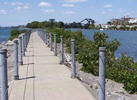
Bird Island Pier looking back at Squaw Island
During this session we will examine historic Black Rock from Unity (Squaw) Island and the Bird Island Pier. Black Rock extended from School Street, which runs into Niagara near the Peace Bridge, to about as far as Austin Street, which is beyond the International Bridge to Canada. Old Black Rock's western border was the Niagara River and its eastern line was approximately the eastern boundary of the Mile Strip. New York State had bought this mile-wide swath from the Seneca Indians in 1802 and shortly afterward sold lots on this land. North of where the Scajaquada Creek empties into the Niagara River near Tonawanda Street and Forest was called Lower Black Rock, and the area south of that creek mouth was termed Upper Black Rock.
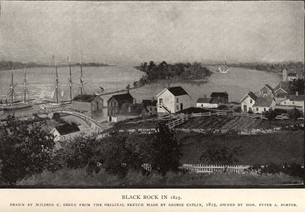
The black rock itself from which the locality took its name lay in the river just north of the Peace Bridge. It was a large triangular shelf of darkish limestone that jutted about 200 feet from the shore and rose four or five feet above the water. It was river-current-sheltered and an ideal docking place for boats and for the oar-propelled ferry across to Canada.
But the black rock was dynamited away in the early 1820s to make way for the Erie Canal bed that paralleled the shore and proceeded via the Buffalo River to Buffalo Harbor.
The commercial and social center of Black Rock at that time was the Niagara Street, Breckenridge and West Ferry vicinity - about where the Rich Products complex lies today. After the removal of "the rock," the ferry operated from Squaw Island at the foot of West Ferry Street.
Black Rock Links
Broderick Park Link
Black Rock Historical Society
The Black Rock Historical Society's mission is to educate the public about the history of the communities of Black Rock, Grant/Amherst, Riverside and West Hertel in the City of Buffalo, New York. The society collects, preserves, interprets and exhibits information about these communities, to inspire residents and visitors and to instill a deeper appreciation of the important role that the residents of these communities have played in local, national and world history.
Accomplishments
Accomplishments
- Exhibit panels featuring market Square, War of 1812, Growth of Railroads and the Erie Canal.
- Black Rock Heritage Trail Brochures.
- Black Rock Heritage Mural at Tonawanda & Amherst Streets.
- Historic Markers and Interpretive Signage.
- War of 1812 Speakers Series at the Buffalo History Museum
- Award Winning Black Rock Historic Photo Project
Buffalo News Article on Black Rock Historical Society Grand Opening May 2015
Black Rock Heritage Trail Tour Map
| blackrockbrochuretrailmap.pdf |
Scajaquada Historic Trail Tour Map
| scajaquadatrailmap.pdf |
Session Objectives
Black Rock:
- Explore resources available at Buffalo Maritime Center, Black Rock Historical Society, Unity Island and Bird island Pier
- Create “Text Based Projects” aligned with the NYS Social Studies Standards & the CCLS to use as assessments with students.
- Analyze the impact that the Black Rock Section of Buffalo, NY and it’s distinct components had on WNY history, NYS history and US history
- Use the http://btcwaterfronthistory.weebly.com/index.html website to facilitate classroom discussions
